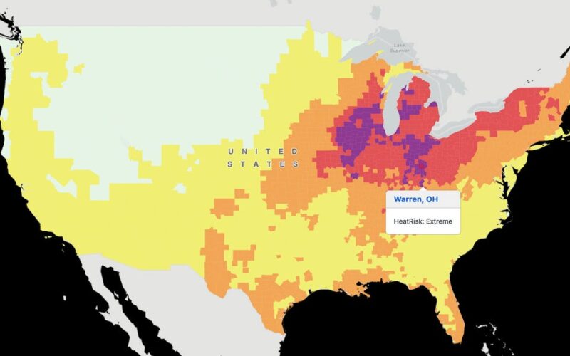
With temperatures rising alongside your electric bills, the CDC and National Weather Service launched a HeatRisk map to help you determine whether you can handle the heat.
By plugging in your ZIP code, you can find out just how scorching your area will be for the next seven days — and the possible risks. The map, which we first spotted thanks to The Verge, presents a seven-day forecast of the potential threat of heat-related impacts across the US.
The heat index follows a five-tier color-numeric scale from green (little to no risk) to magenta (extreme). Without adequate cooling and hydration, anyone can be impacted at the level of magenta or red (major), the CDC and NWS said.
Along with possible elevated risks for heat complications, HeatRisk also takes into consideration the duration of the heat and how unusual it is for that time of year and area.
If you remember last summer’s record-breaking heat, be prepared for some déjà vu in the next few months.
The NWS reported that much of the Midwest to Northeast is set to see “the hottest temperatures of the summer,” with possible daily and monthly high-temperature records for June. The heat wave’s duration is “potentially the longest experienced in decades for some locations,” the agency said.
Record-breaking #heat is forecast to expand from the Midwest and Great Lakes to the Northeast this week, potentially lingering through early next week. The duration of this heat wave is notable and potentially the longest experienced in decades for some locations. pic.twitter.com/4nJ1PS4qih
— NWS Weather Prediction Center (@NWSWPC) June 16, 2024
Heat waves aren’t just annoying — they can sometimes be deadly.
Last year, there were an estimated 2,300 heat-related deaths in the US, with many suffering from a lack of access to air conditioning. To avoid heat illnesses such as heat stroke and exhaustion, the NWS suggests people drink plenty of water even if they don’t feel thirsty and wear loose-fitting, light-colored clothing.
The most vulnerable groups to heat include young children and infants since their bodies are less adaptable to heat, and older adults, especially those who take certain medications that can interfere with body temperature regulation. Other high-risk individuals include people with chronic medical conditions and pregnant women.
Extreme heat levels can also impact infrastructure, including transportation, utilities, and agriculture. It can strain electrical grids, water resources, and certain aircraft operational limits. A 2021 study indicated that high heat in the US could result in an estimated $100 billion in reduced productivity annually.
Following the launch of its initial prototype for California only in 2013, HeatRisk is now the first variation to include information from the CDC about the health impacts of heat. HeatRisk is still an “experimental product,” and the NWS is accepting public feedback via survey through September 30.
Source link
lol

